National Aeronautics and Space Administration
Goddard Space Flight Center
ICESat banner
Science: ICESat Measurements
Science: ICESat Measurements
Questions about climate:
- Is sea level rising?
- Are the Greenland and Antarctic ice sheets growing or shrinking?
- Can ice sheets cause large, rapid changes in sea level?
- Will the ice sheets melt or grow in a warmer climate?
Questions about measuring climatic indicators:
- The Geoscience Laser Altimeter Instrument (GLAS)
- Measuring Earth's Land Surface
- The Greenland Flight Program
- What will GLAS atmospheric measurements tell us?
- Why is cloud radiative feedback important?
- How do polar clouds and haze affect climate?
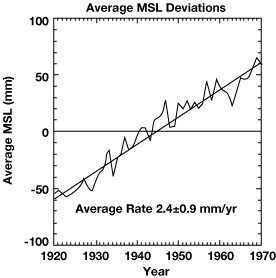
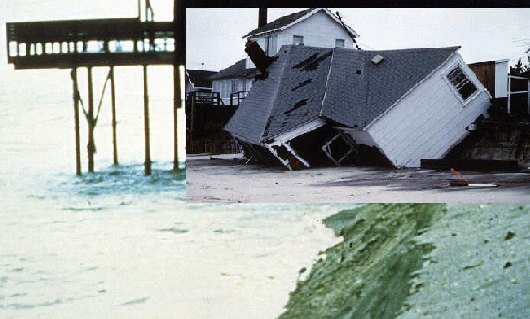
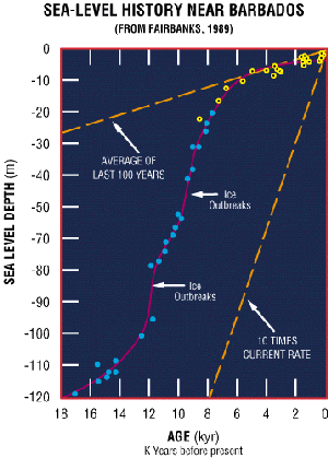
Is Sea Level Rising?
Global sea level is believed to be rising about 2 ± 1 cm every 10 years. About 1/4 of the rise is caused by thermal expansion as the ocean warms. Another 1/4 of the rise is caused by small glaciers melting around the world. Some may also be caused by human activities such as burning trees, filling reservoirs, pumping ground water, and draining wetlands. There is great uncertainty in the rate of sea level rise today because ocean-tide gauge records must be averaged over many decades and corrected for variable ocean dynamics and distortions of Earth's crust.
Are The Greenland and Antartic Ice Sheets Growing or Shrinking?
Fifteen thousand years ago, huge ice sheets covered much of North America and parts of Eurasia. As climate warmed during the end of the last ice age, sea level rose about 125 meters at an annual rate of 2.5 cm for 5000 years. At present, about 8 mm of water from the entire surface of Earth's oceans accumulates as snow on Greenland and Antarctica each year. However, we do not know whetherthe amount of water returned to the oceans in icebergs and meltwater run-off balances the snow accumulation to within ± 30%. If the ice sheets are indeed shrinking by 30%, they would be contributing 2.4 mm/year to sea level rise.
ICESat is designed to detect changes in surface elevation ~ 1 cm/year, in regionsas small as 200 km by 200 km. Overall, a persistent elevation change of 1 cm/year is equivalent to an ice mass imbalance of 5% and 0.4 mm/year of sea level change. Observations of elevation changes over the entireice sheets will enable assessments of the ice mass balance and dynamics in individual drainage basins and major outlet glaciers, as well as forthe entire ice sheets. The continuous satellite observations will also detect interannual changes in the surface mass balance and enable evaluation of whether the changes are caused by recent or long-term changes in climate and/or ice dynamics.
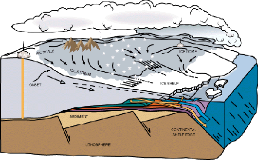
Can Ice Sheets Cause Large, Rapid Changes In Sea Level?
"There remains the possibility that, under the influence of global
warming, the West Antarctic Ice Sheet might become unstable and
surge into the ocean, causing a global rise in sea level."
Earth System Science: A Closer View, 1988
During the climate warming that ended the last ice age 15,000 to 10,000 years ago, several massive outbreaks of ice from the Hudson Bay region spread large amounts of icebergs over the North Atlantic. The ice outbreaks caused sea level to rise over 10 meters in a few hundred years. During the last interglacial warm period -- about 120,000 years ago when climate was even warmer than today and sea level was 6 meters higher -- the West Antarctic ice sheet may have disintegrated.
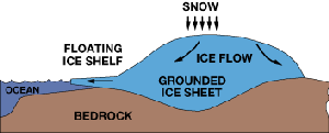
A "marine" ice sheet rests on a bed far below sea level and comprises three components: the slowly flowing main body of the ice sheet; fast-moving ice streams that flow a hundred times faster than the ice next to them; and floating ice shelves, into which the ice streams flow.
Some theorists believe that if the ice shelves were thinned significantly by increased ocean warmth, an important brake on the outflow of ice streams would be removed. This could lead to a greatly accelerated discharge of ice into the ocean with a consequent rise in sea level.
 ICESat is designed to look for early indications of accelerated outflow, which
would necessarily be associated with a rapid lowering of the ice-sheet
surface. Thus, ICESat will provide an early warning many years before
ice breakup could be detected from increased numbers of icebergs in the
ocean.
ICESat is designed to look for early indications of accelerated outflow, which
would necessarily be associated with a rapid lowering of the ice-sheet
surface. Thus, ICESat will provide an early warning many years before
ice breakup could be detected from increased numbers of icebergs in the
ocean.
Will the Ice Sheets Melt or Grow in a Warmer Climate?
More ice will melt and more snow will fall, but...
We do not know which will be stronger: the effects of increased melting at ice sheet margins, or increased snowfall over the entire ice sheet. The lower elevations of the ice sheets will melt more in summer, especially in Greenland. However, a warmer atmosphere carries more moisture, so more snow will fall on the ice sheets causing large areas of the ice sheets to thicken. Changes in atmospheric circulation may also affect the snowfall, as will decreases in the surrounding sea ice that affect the source of moisture for snow over the ice sheets. The change in ice melt/growth rate might be as large as -10% to +10% for each degree of climate warming (-0.8 to +0.8 mm sea level change/year/degree).
ICESat is designed to observe seasonal and interannual variations in surface elevation that are caused by variations in precipitation (snowfall) and surface melting. These data will be used in energy-balance models and to test the results of atmospheric circulation models used to predict climate-induced changes. ICESat should detect changes in mass balance expected for each 1 degree change in polar temperatures (depends on sensitivity estimate). ICESat measurements are essential for making reliable assessments of whether future changes in ice volume will add to the sea level rise, which is already occurring due to the warming and thermal expansion of the oceans and worldwide melting of small glaciers, or whether the ice sheets might grow and absorb a significant part of the predicted sea level rise.
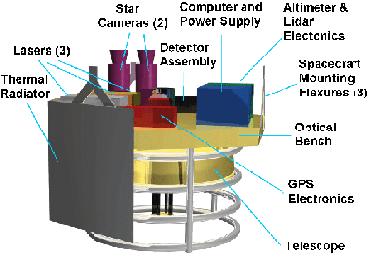
Geoscience Laser Altimeter System
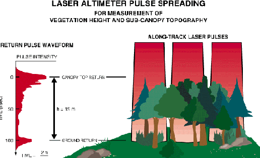
The Geoscience Laser Altimeter System (GLAS) includes a laser system to measure distance, a receiver of signals from the Global Positioning System (GPS) of satellites, and a star-tracker attitude-determination system. The laser will transmit short pulses (4 nano-seconds) of infrared light (1.064 nanometers wavelength) and visible-green light (532 nanometers). Photons reflected back to the spacecraft from the surface of the Earth and from the atmosphere, including the inside of clouds, will be collected in an 80-cm diameter telescope. Laser pulses at 40 times per second will illuminate spots (footprints) 70 meters in diameter, spaced at 170-meter intervals along Earth's surface.
The distance from the spacecraft to clouds and to Earth's surface will be determined from measurements of the time taken for the laser pulses to travel to the reflecting objects and return. The height of the spacecraft above the center of Earth will be determined from information collected by the GPS receiver in GLAS and a GPS network operated around the world for other purposes. The pointing of the laser beam, relative to Earth's center will be determined by the star-tracker system. The knowledge of the laser pointing and the spacecraft position will be combined to calculate the precise location of the footprint on the surface to a few meters' accuracy.
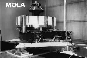
The GLAS laser will be a solid state, diode pumped Nd:YAG (neodymium-yttrium-garnet) system, which has extensive heritage in space applications. A similar laser was built by the McDonnell Douglas corporation for the Mars Observer Laser Altimeter (MOLA), which was designed to map the land topography and polar ice caps of Mars. Similar instrumentation has also been flown on aircraft over the Greenland ice sheet for proof-of-concept experiments. The infrared laser pulses (120 mJ) will be used for ice sheet elevation and land topography. The green pulses (60 mJ) from a laser frequency-doubler will be used for the atmospheric measurements (detection of the small number of photons backscattered from the atmosphere requires the use of photon-counting techniques that use visible-light detectors). The attitude-control system of the spacecraft will keep the laser-beam and telescope pointing toward Earth's center (nadir-direction) using information from the star-trackers and GPS. A small part of the laser beam will be directed into the cameras, so the pointing of the laser beam can be very accurately calculated.
The elevation of the surface at each laser footprint is the height of the spacecraft minus the measured distance to the surface. Over most of the ice sheets, the accuracy of each elevation measurement will be 15 cm. Average ice elevation changes less than 1 cm will be detected by averaging the elevation differences observed at many points in selected regions of the ice sheets. Over land, the vertical accuracy of the elevation measurements will be better than a meter in regions of low slope and up to 10 m in regions of large slopes. Each measurement will represent the average surface elevation over the 70 m laser footprint. Surface roughness within the footprint will be derived from the widening of the return laser pulse.
The pattern of sub-satellite tracks of ICESat will be repeated every 183 days. Separation of the tracks after 183 days will be 15 km at the equator, 11 km at mid-latitudes, and 2.6 km at 80 degrees latitude. During the lifetime of ICESat, interleaving tracks may be added. The satellite will pass within 4 degrees of the poles but not exactly over the poles, so repeat measurements at crossover locations (where ascending tracks of ICESat cross exactly over descending tracks) can be used for analysis of elevation changes. In 183 days, there will several million such crossover points over Antarctica.
ICESAT is being developed by a partnership of NASA, industry, and university teams. The smallest of the new Med-Lite class of rockets, the Taurus, will launch ICESat into an orbit at 600 km altitude and 94 degrees inclination to the equator. GLAS utilizes advanced laser detection and ranging, attitude sensing, and orbital-position-sensing technologies. The spacecraft provides a highly autonomous, inertially stabilized platform with advanced power, guidance, and propulsion systems to maintain the critical performance required for repeated Earth observations. Its designed lifetime is for 3 years of operation with a 5-year goal. Three successive spacecraft will acquire the 15-year data set planned for EOS. The first mission will provide an assessment of the current ice balance and data for prediction models. Additional missions will improve the assessments, monitor changes that might be associated with climate warming, and enable validation or revision of predictions.
The spacecraft data system collects and processes science and spacecraft health/safety data in state-of-the-art solid-state memory. When the satellite establishes contact with the ground antenna, the data are transferred rapidly to the ground with no command interaction. The ground system collects the data from the antenna and converts them into science data products for use by the science community. In addition, fundamental safety data are used to evaluate the satellite's status and plan occasional orbital maneuvers.
Measuring Earth's Land Surface
ICESat will measure the elevation of Earth's land surface with unprecedented accuracy and global coverage. Maps of Earth's topography are needed for a variety of scientific studies in geology, hydrology, volcanology, population dynamics, land erosion, biology, and meteorology. Accurate maps are also necessary for a variety of commercial, resource-development, land-use, navigation, and other applications. The figure of Iceland displays a digital-elevation model, with surface-slope times elevation in color and a spatial resolution of about 100 m. However, the topography of much of Earth's surface is hardly known. Changes in land elevation, which can be determined during the life of ICESat, will be especially valuable.
The high-vertical resolution profiles of surface elevation from GLAS will provide vertical and horizontal control points for topographic maps obtained from conventional stereo-photogrammetry or radar interferometry. The control points will have a common coordinate system, precisely referenced to the center-of-mass of Earth. Such data are essential to tie together the disparate reference surfaces that limit our understanding of global topography. ICESat data collected over land surfaces will therefore enhance data collected by ground-based and airborne surveys, with the added valuable benefit of providing long-term time series of topographic changes, which are especially difficult to obtain by other techniques.
The profiles of land surface elevation will be used directly for solving a variety of problems in surface geology and hydrology. All major geomorphic systems on Earth will be characterized by statistical analysis of within-footprint surface roughness and short-wavelength topographic profiles. Topographic signatures can be obtained at sub-kilometer length scales of the most dynamic surface processes, including active volcanism, coastal erosion, and mass transport and wasting. These signatures will be analyzed as a function of season, local climate, geological context, and intensity of geomorphic processing. Continental-scale topography measurements will be valuable for sediment transfer studies, revealing gradients into sediment sinks and volumes transferred. For example, the great sand sheet migrations of northern Africa and central Asia and their relation to desertification can be characterized. Similarly, volcanic processes in Alaska and the Aleutian islands will be monitored more frequently than standard airborne techniques allow, thereby providing long-term time series to investigate geomorphic changes.
In vegetation areas, the pulse digitization capability will be used to separate the partial reflection of the vegetation canopy from the underlying vegetation structure and ground surface, and thereby determinevegetation height. Furthermore, the relative reflectivity of both the 1064 nm and 532 nm pulses will provide a vegetation index that is independent of sunlight bi-directional reflectance.
Greenland Flight Program
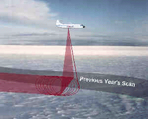
In 1991, NASA began an airborne program of over-ice laser altimetry to determine how accurately we can measure ice-surface elevations using an airborne scanning laser altimeter in combination with onboard GPS receivers to provide very precise aircraft trajectories and ring-laser gyro systems to correct for aircraft attitude. A secondary objective was to assess how well the aircraft could be navigated using the GPS units to guide the autopilot. By1993, systematic identification and resolution of all error sources, combined with an improving constellation of GPS spacecraft, had reduced errors in derived ice-surface elevations to the 10-cm level. Flight-track repeatability, aided by the onboard GPS units, was about 50 meters -- well within the 150-meter swath of the scanning laser. This ensures overlapping data swaths from repeat flights over the same routes, so that changes in ice-surface elevation during the interim between flights can be readily measured.
Armed with this capability, in 1993/1994 NASA flew a network of flight lines that included all the major ice drainage basins on the Greenland Ice sheet. Although spacing between adjacent flight lines is much larger than will be provided by GLAS, these measurements represent a baseline data set against which all future precise measurements can be compared. Thus, very soon after GLAS launch, we will be able to provide first estimates of ice thickening/thinning for all major Greenland drainage basins. Already, this program is yielding early results. Comparison with precise ice-surface elevations obtained using a geoceiver in 1980 at stake arrays in southern Greenland indicates a thickening of as much as a meter between 1980 and 1993. A repeat airborne survey of the 1993/94 flight lines is planned for 1997/98, with annual flights along some lines to investigate interannual variability. There are no plans for airborne surveys of the much larger Antarctic ice sheet. Sheer size and inaccessibility, combined with severe weather conditions and remoteness from suitable airstrips, make a comprehensive survey of Antarctica both costly and dangerous. The first data point on Antarctic ice thickness change must await the launch of GLAS.
Additional information on measuring ice from the air is available from the Airborne TopographicalMapping Project
What Will Glas Atmospheric Measurements Tell Us?
GLAS, the first laser-ranging (lidar) instrument for continuous global observations of Earth, will make unique atmospheric observations as an important component of the EOS climate change program. In the figure below, laser measurements of clouds obtained from an aircraft have been adjusted to simulate measurements to be made with the spaceborne GLAS, demonstrating the capability of ICESat to observe the vertical distribution of clouds and aerosols. The strongest backscatter signals are white, changing to blue for no backscatter signal.
High-cirrus clouds, typically found between heights of 11 and 15 km, generally exhibit lower scattering. The data simulation shows that even tenuous, thin cloud layers will be detected by GLAS. Such sub-visible-cirrus clouds (which are difficult or impossible to detect using passive techniques) may be very important in determining the atmospheric radiative balance. Aerosols in lower levels of the atmosphere will also be detected.
ICESAT will provide global lidar observations of cloud heights and bases, cloud optical properties, planetary boundary layer (PBL) heights, lifting condensation levels (LCL), tropospheric and stratospheric aerosols, and polar stratospheric clouds. When combined with passive radiometric observations, important meteorological parameters such as the optical thickness of cirrus clouds and the moisture content of the PBL will be inferred. In addition, the lidar data will be valuable for supplementing and validating EOS passive sensors for clouds.
Why Is Cloud Radiative Feedback Important?
GLAS atmospheric observations are important for understanding Earth's climate. They will provide direct, unambiguous measurements of the height of cloud layers in the atmosphere. Clouds have two radiative effects on Earth's temperature that tend to act in opposite ways. Clouds cool the atmosphere and Earth's surface by reflecting solar radiation back to space, but they also heat the atmosphere by absorbing infrared energy that is emitted from the surface and escapes to space in the absence of clouds. The net effect on heating and cooling Earth depends strongly on the vertical distribution of clouds. High clouds are cooler than low clouds and therefore radiate less energy to space. The vertical distribution of the heating and cooling also affects the feedback to atmospheric circulation and cloud formation. Knowledge of the height, coverage, and thickness of cloud layers is essential for both modeling the complicated feedback processes between clouds, radiation, and climate, and understanding climate change.
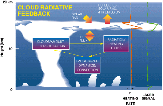
The vertical distribution of cloud cover to be derived from GLAS laser profiles will be a critical improvement for calculation of atmospheric heating/cooling rates. Cloud height structures are not adequately obtained by other techniques. Lidar data from all regions of the earth will provide scientists with an unprecedented global data set on the true vertical structure of clouds, and aerosols, thereby greatly aiding research efforts aimed at understanding the effects of clouds and aerosols on climate and their role in climate change. In the figure below, optically dense clouds (shown as white) give the strongest laser backscatter signal.
How Do Polar Clouds And Haze Affect Climate?
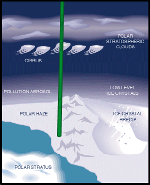
In polar regions, the atmospheric observations of GLAS will be especially important. The very low temperatures and long periods of darkness in the polar regions limit standard satellite techniques, which are based on passive sensing. However, for the same reasons, polar clouds are very important for understanding weather in polar regions and the relation to Earth's climate. The GLAS instrument will be uniquely sensitive to observing cloud cover and important processes of the polar atmosphere. These include polar stratospheric clouds, which effect the ozone hole, and a phenomenon known as clear-air, ice-crystal precipitation, which is thought to be a major factor in the mass balance of the Antarctic ice sheet. The atmospheric channel of GLAS will also help researchers interpret laser signals obtained from the ice sheet surface in the presence of low clouds, fog, or blowing snow.
Follow me on Twitter!


- NASA Official: Dr. H. J. Zwally
- Webmaster: Jairo Santana
- Page Last Updated: Jul 27, 2016